NoCo Chris
  • Home
  • 2012 & 2013 TRs
    • 2012 Trip Reports >
      • UN 6674 'Triangulation Point'
      • Shipler Mountain/Trail Ridge
      • Storm Peak
      • Panorama Peak and Sugarloaf Mountain
      • Lookout Mtn/Horsetooth Pk
      • Thatchtop
      • Green Mountain and Chickaree Lake
      • UN 7432 'Kelly Flats Peak'
      • Mount Bierstadt and Sawtooth Ridge
      • UN 6176
      • Clark Peak
      • Prohibition Mtn, Pingree Hill, UN 8079, UN 9740
      • "The Sabre"
      • Moriah, Manhead, 8340, 8555, 8435
      • Desolation Peaks
      • Round Butte
      • Pole Hill
      • The Needles and Lumpy Ridge HP
      • Pine Ridge
    • 2013 Trip Reports >
      • Eagle Rock and UN 8220
      • Kenny Mountain
      • Deer Ridge East
      • UN 8820
      • Dark Mountain
      • Mount Dickinson
      • UN 11002
      • Little Matterhorn
      • Snowdrift Peak
      • Crystal Mountain Group
      • Cameron Peak
      • Copeland Mountain
      • 8300, 8161, 8140, Sheep Mountain
      • UN 7383
      • UN 9986 and UN 9634
      • UN 10100 and UN 10013
  • 2014 Trip Reports
    • Prospect Mountain and Checkerboard Rock
    • UN 6823 and 6176
    • Panorama Peak
    • Livermore Mountain and UN 6975
    • Round Mountain, UNs 8092 & 8310
    • Fairchild Mountain
    • DeCaLibron
    • Ramsay, Sugarloaf and Skull
    • Sheep Mountain and Rock
    • Laramie-Poudre Tunnel and UN 10060
  • 2015 Trip Reports
    • Storm Mountain
    • UN 6945
    • UNs 7231 and 6485
    • UN 7380
    • Turkey Roost
    • UNs 9460S, 9495 & 10088
    • Nokhu Crags
    • High Dune
    • San Luis Peak
    • Bald Mountains and Laramie Mtns. HP
    • Mount Ida, Chief Cheley Peak, UN 12820
    • Lookout Mountain and UN 10582
    • Hell Canyon
    • UN 10020
    • Palisade Mountain
  • 2016 Trip Reports
    • UN 6740
    • UNs 9166 and 8806
    • The Monastery
    • Lonetree Mountain
  • External Sites
March 2012. Additional details and overview can be found here
Picture
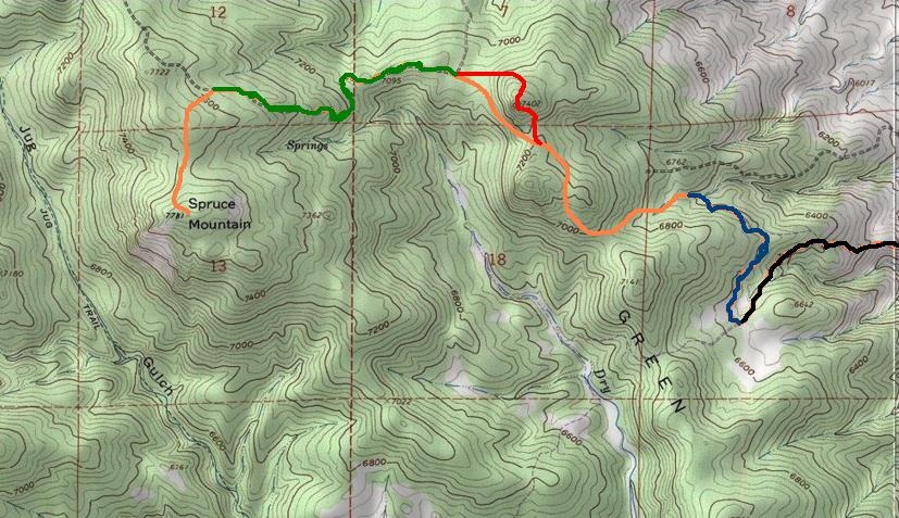
Orange sections are off trail, Red is Green Ridge side trip, Green is Forest Service Road 348, Blue is DR trail, Black is Powerline trail. Bobcat Ridge TH lies several miles southeast.
Powered by Create your own unique website with customizable templates.